Mud Map
What is a Mud Map?
The term mud map is an old Australian bush saying. It dates back to the early years of European settlement when much of the continent was still unexplored and unchartered by white men.
To outline directions to each other, when outback travellers met up by chance they used to draw maps in the dirt or in the mud after it had rained. These in turn became known as mud maps.
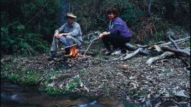
In those days it was a lonely life droving and travelling around the bush and the chance to stop and chat for a while around a campfire with a friendly face was something to be savoured and enjoyed.
What is a Mud Map?
Why a Mud Map?
More to a Mud Map?
Simply a Mud Map?

Mud Map : what it means
Often while sitting around a campfire at night fellow outback travellers would share stories, trade information and pass on the latest news. This news may have been the latest gold rush or possibly a recent flood and so the map drawn on the ground became the focal point for describing the event and where it was.
The term mud map has remained in the Australian language particularly with people from the bush. These days however the maps are usually hand drawn on paper although you may occasionally see someone squat down and actually draw a map in the mud.
MudMaps : travel with experience
While maps drawn in the mud have largely been replaced by printed maps and electronic copies, the local knowledge of the outback area which was so vital in days gone by must still be passed on by the experienced themselves.
Our own maps reside in the Maps Collection of the National Library of Australia depicts digitally this cross over from mud to electronic


